Sunday, April 15, 2012
The Caythorpe Canter- Event Report
When I noticed that the Caythorpe Canter was being run yesterday, I couldn't resist entering it. I've done this one a few times, but not since 2008 when I did it in an amazing (for me!) 6 hours 10 minutes. As I had had a few years break and it is a fairly local event for me now, I decided to revisit it.
Caythorpe village is the other side of Grantham and around 40 minutes drive, but as the event doesn't start until 9am I didn't have to get up too early. As usual I was early and parked up in the field next to the Village Hall. I'd entered online, but when I went to register I had been given a number for the short (14 mile) route. Luckily it was soon sorted by the ladies on the 'register on the day' desk, who re-registered me on the 26.2 mile route and gave me a new number plus red wrist band as opposed to the blue ones worn by those doing the shorter route.
It was gloriously sunny as we gathered around the start- the 14 mile route was to start half an hour later. There weren't many of us doing the 26.2 mile option, and most of those who were doing it were runners. Our starter gave us a few announcements before we started, including a warning that one of the railway bridges we were to go under had quite a lot of water in it.
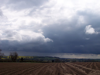
At 9am we were off, and heading out of the village in the wake of the runners, along a long track. This pretty much characterised the terrain most of the day- long tracks across fields, sweeping views and minor roads.

 Two ladies came past who were walking incredibly fast, and I was passed by a chap who's son was running the shorter distance with a group of cadets, all in full camouflage gear and with heavy packs.
After a long stretch of track, there was a brief walk along a road before reaching a go-kart track. Our path went around the side of the track, which was hidden behind a bank of earth- the go-karts could be heard whizzing around like a bunch of angry gnats.

 The first of the 14 mile runners started coming past, and I saw a steady stream of runners until the routes split. It was sunny but chilly, a perfect Spring morning for walking. I had a few short jogs as the terrain was fairly easy.
After more tracks, and an ornamental lake, I reached the village of Stubton and the first checkpoint at 6 miles.
 I took advantage of the choccy bars and left the village. Shortly afterwards, the routes split- the longer route turning right up a track to eventually reach a bridge under a busy railway line. It was still flat, and I was feeling ok, so I had a jog along the track.
 After the bridge, there's another long section of track and then a road walk into the village of Hougham. I remember being impressed with Hougham last time I did this- it is a pretty little village, and the route took me past the church and along land belonging to Hougham Manor via a permissive path and two foot bridges.
 Hougham- View From The Foot Bridge
A short hop through another field brought me to Marston, where I tucked into a chocolate bar I had liberated from the first checkpoint. Another road and then track followed, until I rounded the sewage works (pleasant!) and came to the railway bridge we had been warned about. It was full of ankle deep water and there was no way I was going to keep my feet dry, so I just gritted my teeth and waded through- God it was cold!!
Luckily the next part of the route is rather lovely- following a meandering track through a huge field of crops, by a river initially and then turning away from it to the next checkpoint in Barkston at 14 miles.


This checkpint is delightful; it is in the village school and there were hot drinks on offer, plus peanut butter sandwiches. There was also a large tub of Celebrations, and I was persuaded to take some with me (ok I didn't need much persuading!!)
I knew there was a tough climb ahead, and it was as tough as I remembered- a very steep road uphill before levelling out and becoming a track, passing an airfield before reaching a minor road leading to the Roman Road of Ermine Street. I felt fairly strong and managed to jog most of this.
The next part of the route can be a little difficult to navigate, and although much of the route was marked with signs and red and white tape, the markers were absent on this stretch. It was quite cloudy now and the sky was becoming quite ominously dark, I fully expected to get wet at any second! After a long trudge uphill through a large field, there is a gap into the next field which is easily missed. Luckily for me, I found it- the next field was lovely, it was full of hares- one bounded along in the crops next to me, keeping pace with me for a few seconds.
Just as I reached the road, the heavens opened and it started to hail. I made myself jog- at least it was downhill! It felt like a bit of a slog- as the road was straight I could see the cross roads I was aiming for but they never seemed to get any closer!
Finally I reached it, just as it stopped raining, and after a brief climb was on a lovely path through woods, leading to the village of Ancaster and the final checkpoint.

At Ancaster there was cold rice pudding and even more Celebrations! I allowed myself the luxury of another hot coffee and took a banana with me to sustain me for the final push.
The route climbed out of Ancaster, over a level crossing and along another long track. The sky started to become threatingly dark again but luckily stayed dry- for now!
 I went slightly wrong here- the route description told me to go through two hedge gaps and ahead to a track, but for some reason my mind didn't compute the 'go ahead to a track' bit and I turned right immediately after the second gap instead- there seem to be a whole network of tracks around these parts! I realised I had gone wrong when the track petered out into a huge ploughed field, instead of the junction of tracks I was expecting. After a couple of moments of quiet despair I noticed a group of cyclists at the top of the field to my left, realised my mistake and walked up to join the track. My legs and feet had had enough at this stage and I was ready to finish.
There was a water point at the point where the track meets the road- it was obviously a very quiet road, as the organisers had left a table next to the road with bottles of water, so I slipped one in my pack and was treated to the sight of some really free range chickens, wandering around quite happily.

As I was hobbling down the road a lady drove past, stopped and said that she was looking for the people still on the course- she informed me that there were 7 people behind me.
It was mostly downhill to Caythorpe, and just as I reached the village it started to rain. There was a proper finish sign so I ran under it, to the cheers of one of the organisers and a group of children, and then went into the Village Hall for lovely sandwiches and a selection of home made cakes- so nice I had to try three! The volunteers were lovely, nothing was too much trouble for them. I was even in time to watch the Grand National- I knew how those horses felt!
My time was 7 hours 10 minutes, which is very quick for me- it seems to be quite a fast route, mainly because apart from a couple of steep climbs the terrain is quite easy.
I have had an email confirming my entry for the Leaden Boot on May, so that may well be my next event.
Caythorpe village is the other side of Grantham and around 40 minutes drive, but as the event doesn't start until 9am I didn't have to get up too early. As usual I was early and parked up in the field next to the Village Hall. I'd entered online, but when I went to register I had been given a number for the short (14 mile) route. Luckily it was soon sorted by the ladies on the 'register on the day' desk, who re-registered me on the 26.2 mile route and gave me a new number plus red wrist band as opposed to the blue ones worn by those doing the shorter route.
It was gloriously sunny as we gathered around the start- the 14 mile route was to start half an hour later. There weren't many of us doing the 26.2 mile option, and most of those who were doing it were runners. Our starter gave us a few announcements before we started, including a warning that one of the railway bridges we were to go under had quite a lot of water in it.
At 9am we were off, and heading out of the village in the wake of the runners, along a long track. This pretty much characterised the terrain most of the day- long tracks across fields, sweeping views and minor roads.


After a long stretch of track, there was a brief walk along a road before reaching a go-kart track. Our path went around the side of the track, which was hidden behind a bank of earth- the go-karts could be heard whizzing around like a bunch of angry gnats.


After more tracks, and an ornamental lake, I reached the village of Stubton and the first checkpoint at 6 miles.


A short hop through another field brought me to Marston, where I tucked into a chocolate bar I had liberated from the first checkpoint. Another road and then track followed, until I rounded the sewage works (pleasant!) and came to the railway bridge we had been warned about. It was full of ankle deep water and there was no way I was going to keep my feet dry, so I just gritted my teeth and waded through- God it was cold!!
Luckily the next part of the route is rather lovely- following a meandering track through a huge field of crops, by a river initially and then turning away from it to the next checkpoint in Barkston at 14 miles.


This checkpint is delightful; it is in the village school and there were hot drinks on offer, plus peanut butter sandwiches. There was also a large tub of Celebrations, and I was persuaded to take some with me (ok I didn't need much persuading!!)
I knew there was a tough climb ahead, and it was as tough as I remembered- a very steep road uphill before levelling out and becoming a track, passing an airfield before reaching a minor road leading to the Roman Road of Ermine Street. I felt fairly strong and managed to jog most of this.
The next part of the route can be a little difficult to navigate, and although much of the route was marked with signs and red and white tape, the markers were absent on this stretch. It was quite cloudy now and the sky was becoming quite ominously dark, I fully expected to get wet at any second! After a long trudge uphill through a large field, there is a gap into the next field which is easily missed. Luckily for me, I found it- the next field was lovely, it was full of hares- one bounded along in the crops next to me, keeping pace with me for a few seconds.
Just as I reached the road, the heavens opened and it started to hail. I made myself jog- at least it was downhill! It felt like a bit of a slog- as the road was straight I could see the cross roads I was aiming for but they never seemed to get any closer!
Finally I reached it, just as it stopped raining, and after a brief climb was on a lovely path through woods, leading to the village of Ancaster and the final checkpoint.

At Ancaster there was cold rice pudding and even more Celebrations! I allowed myself the luxury of another hot coffee and took a banana with me to sustain me for the final push.
The route climbed out of Ancaster, over a level crossing and along another long track. The sky started to become threatingly dark again but luckily stayed dry- for now!


There was a water point at the point where the track meets the road- it was obviously a very quiet road, as the organisers had left a table next to the road with bottles of water, so I slipped one in my pack and was treated to the sight of some really free range chickens, wandering around quite happily.

As I was hobbling down the road a lady drove past, stopped and said that she was looking for the people still on the course- she informed me that there were 7 people behind me.
It was mostly downhill to Caythorpe, and just as I reached the village it started to rain. There was a proper finish sign so I ran under it, to the cheers of one of the organisers and a group of children, and then went into the Village Hall for lovely sandwiches and a selection of home made cakes- so nice I had to try three! The volunteers were lovely, nothing was too much trouble for them. I was even in time to watch the Grand National- I knew how those horses felt!
My time was 7 hours 10 minutes, which is very quick for me- it seems to be quite a fast route, mainly because apart from a couple of steep climbs the terrain is quite easy.
I have had an email confirming my entry for the Leaden Boot on May, so that may well be my next event.
Labels: Caythorpe Canter
Comments:
<< Home
Well done Steph, an very comprehensive write up.
It looks a good event.
The Leaden Boot is another excellent event, but it did seem longer than the advertised 26miles.
It has some tough climbs, but is well worth it.
It looks a good event.
The Leaden Boot is another excellent event, but it did seem longer than the advertised 26miles.
It has some tough climbs, but is well worth it.

Thanks Ross, loking forward to the Leaden Boot- not done it before.
Well done on your London result, looking forward to reading your write up!
Post a Comment
Well done on your London result, looking forward to reading your write up!
<< Home
![]()
